Maps / continentiam % Updated: 16 June
Ut ego expectatur Pacifici Litus adit Iulius conventus Lepidopterists’ Societatis. Hoc anno fieri turpis Prescott, de 2 north of horis Phoenix. Et quantum ex paucis in Arizona nec igne. Im 'certus vos omnes audivimus de ingens ignes nunc, Sed hic update ex paulo biologicum conspicua. Maxime ut omnes gratias agere firefighters periclitantur animas ad proelium his wildfires.
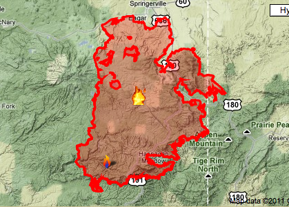
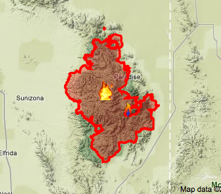
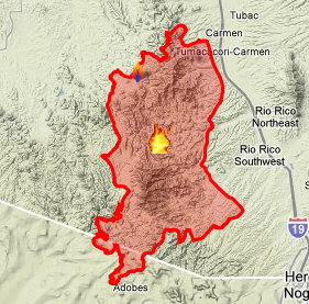
Nam aliquam causam non potui link to Interactive Maps directe a Inciweb Site, Sed velit sequi links ut explorarent amplius. Dum boni Interactive Maps harum ignes Google Maps, Sunt pauci dies. Infra sunt screen-captures de maps minus est 12 horis annorum.
Ignis 1: Maximus unum, Valle ignis est 20% 29% continetur, Humanum fecit et factum est ardens in 15 diebus. Ego fuerat sperans ad colligendis circa oppidum Greer et Alpine, Sed utrumque ignis cito. Alba Montes regionem Arizona est a teneant mixtio zona inter meridionali deserto speciei et scopulos montes – Rare tinea me sperans ut hic, ALICLICUS ASPERSA, et verisimile evadere me adhuc hoc anno.
Ignis 2: Horseshoe 2 Ignis. 60% continetur, human caused, burning for over 37 diebus. This fire has consumed nearly the entirety of the Chiricahua Mountains, save for the famous Southwestern Research Station. The news report is a few weeks old, but thankfully I doubt anything has happened to the station since that would have made headlines quickly (at least in the biology community). Aside from notable endangered species (2), the upper-most peaks of this range have recently revealed handfuls of impressively large and beautiful new species of Lepidoptera: Lithophane leeae, Chiricahua lichenaria (new genus, species novae), Eupithica species, Grammia allectans (old sp, but only known in this region) – amongst other yet to be named ones! It is hypothesized that since only the highest peaks are revealing these impressive species that they are attenuated populations from the adjacent mountains in northern Mexico. Since every high peak has now burned, it is likely that some of these may now be extirpated from the US.
Ignis 3: Murphy Complex Fire. 90% continetur, human caused, burning for 15 diebus. This fire has burned some of the most famous collecting sites in all of Arizona – comprehendo Pena Blanca, Sycamore Canyon and California Gulch. The birders know Cal Gulch because it is one of the only US locations for the five-striped sparrow et elegant trogon, which may not be so happy now.
Without getting too deep into the politics and controversy surrounding wildfire, for the most part nature has evolved to cope with these events. While current management policies may be flawed, there will be a fascinating succession of species over the coming decades. Each location will have burned differently and will experience different fluctuations of species as plants recolonize. I am most concerned about the Chiricahua fire since all of the high elevation areas have burned, leaving zero areas of similar habitat for recolonization events. Hopefully many of these newer species range into Mexico, but the possibility of losing an unknown endemic still exists. Alternatively, these fires could be a positive event and lead to stronger populations of some species or even colonization by other unknown Mexican animals. More likely than not each species will respond different and it will be fascinating to monitor the progress over the long recovery.


Good to hear someone raise the topic of habitat change and possible new species in the Chiricahua Mountains. While it may not be pretty, habitat reorganization due to fire does not equate to the elimination of habitat.