Arizona Eftirlitstími

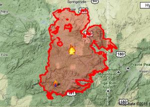
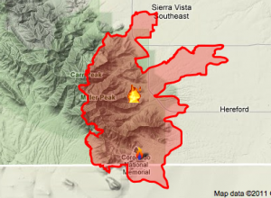
Map/% updated June 20, 6pm.

Updates to the maps and containment percentages have been made to my earlier post. Here is a map of the 4th fire burning in SE Arizona, the Monument fire. This one is only 10% 17% 15% 27% contained and is burning in the southern end of the Huachuca Mountains . . . → Lesa meira: Arizona Eftirlitstími

Arizona á eldinn

Kort / innilokun % Uppfært: 16 Júní

Eins júlí nálgast ég að vera að hlakka til Pacific Coast fundi dauð fiðrildi’ Samfélag. Þetta árið verður hún haldin í Prescott Arizona, um 2 klst norður af Phoenix. And as of this moment it is one of the few places in Arizona not on fire. . . . → Lesa meira: Arizona á eldinn

Vestur-Arizona

Fyrir nokkrum mánuðum síðan var ég úti að safna í vesturhluta Arizona og tókst ekki að fylgja eftir með myndum eða uppfærslum á þeirri ferð. Jæja, það heppnaðist vel og vel þess virði að komast þangað! Ég var að leita að Crambid mölflugu í fjöllunum í Kofa National Wildlife Refuge (sérstakar þakkir . . . → Lesa meira: Vestur-Arizona

Á vellinum

One of the perks of being an entomologist is traveling and collecting. I put a few thousand miles on the car every summer and these are two of the best places in Arizona to collect. The top image is from the Baboquivari Mountains (Baboquivari Peak in the middle), Brown Canyon Research Station. . . . → Lesa meira: Á vellinum